|
2-23-99 Tuesday The BLM campgrounds at Quartzsite are still active. Many, many snowbirds and other long term campers are enjoying the great weather and peaceful, quiet, lazy days. One would not think it was deserted out here unless one had experienced the furor of two weeks ago. There are still hundreds of rigs parked helter-skelter all over the four LTVA grounds and more in the 14 day limit areas. What a place. There is no other like it. Quartzsite, the town, is peaceful. Vendors have for the most part packed their wares and moved on. The ones that remain are either permanent residents or vendors who are headed somewhere with no hurry in their schedule. Someone said there are famous boat races at Lake Havasu this weekend, so a lot of vendors probably went there. Resident merchants are catching their breath, straightening up their stores, laying off their extra employees and looking forward to a beautiful desert spring followed by summer's heat that some feel worthy of Hell while others say... 'Hey, you get used to it!' I don't think so. But those that stay hibernate inside like bears in the wintertime.
Activity: Campfire.
It was really wonderful to have the campfire. Another great first. And as Harold says, you wouldn't get to tellin' the great stories if there was no fire to gaze into.
2-25-99 Thursday Activity: Departure Day Before we departed I returned Harold Drummond's RV poem to him and took a picture of he and Marie... and their rig. When we were ready to pull out I drove the rig to the dump station and then to the water faucets for practice. Then we headed north to Quartzsite and west to Blythe, CA. The wind was picking up as we traveled. In Blythe we stopped at the Employment Development Department. They said I would have to have my last employer's name, address, zip and phone number. I told the woman I'd have to go home and get it. She said, "How far away is your house?" I said (pointing out the front door) "Right there in your parking lot." (Some folks have difficulty in grasping the concept of full-timing.) Next stop was Albertsons which appears to be the only large grocery store in Blythe. It is a really nice one and had just about everything we needed and more. We got a couple of chef's salads and ate them for lunch after putting the food away. Nothing like taking your house to the store along. Back on the ten freeway we head west again, gradually gaining altitude. Obvious agriculture diminished into what appeared to be 'tumbleweed farms' with mountains all around the horizon. The desert between Blythe and Desert Center looks more like 'real' desert, in contrast with high desert as in Antelope Valley or the desert around Quartzsite and the Parker Strip. The wind blows sand into small piles and those stair-step ridges form on the piles. The sand is the color always depicted as desert in the movies although it is not in huge, higher-than-building heaps as in Death Valley or the Sahara. It may have been like that in Quartzsite once upon a time, but I think it all blew away to leave the nice rock surface for people to park on. As we progressed along we could see a zeppelin up ahead and wondered if it was the one we had seen in Arizona. It didn't seem to be moving and we thought it might be tethered, but as we got nearer it was obvious it was not. The wind over the pass was quite strong at that point and the zeppelin seemed to be suspended there in the air unable to go further.
With permission from the restaurant manager we dry camped in the desert behind the Patton Museum... except for the traffic passing on the Ten Freeway it was quiet... just us and a dozen old rusting tanks with their memories. Television reception was non-existent.. but, hey, the price was right... $0. 2-26-99 Friday
Admission was $4 for adults, $3 for seniors. You could look around the entrance room for free. An inept volunteer at the admission/gift register did her best to confuse everyone. The museum is interesting with mementos from all wars but mostly WW II. An interesting, informative 26 minute video tells the story of the Patton Training grounds that spread over southern California, Nevada and Arizona. Patton recognized the need to train our military to fight in the desert and this place was perfect. I was particularly fascinated with the shell art display. Soldiers, with noting to do in foxholes, etc., took the empty shell casings and forged them into vases and other containers and hammered and etched designs into them; polished them up to nice shining brass.. Amazing.
On the west side of Parker Strip by Parker Dam we had seen the start of the aqueduct where the water leaves the Colorado River and heads into California, so it was fun to see just where the pipes went from there. The Colorado River Aqueduct runs through what became Patton's huge desert training facility established shortly after the United States was drawn into World War II. When Patton needed water for his men he tapped into the aqueduct. He sent a party to the water district in Los Angeles to seek permission to tap it and they were told the paperwork would take a while. The emissaries told the water district to do whatever they had to do because Patton had already tapped in, and if there was a problem to let them know. (Forgiveness is often easier to obtain than permission.) I stopped at the gift counter on the way out of the museum to get a pin, for Pinney, my travel-pin teddybear. I overheard the volunteer tell a woman inquiring if it was possible to reach 29 Palms by crossing through Joshua Tree National Forest as was indicated on a map she had. The volunteer told her no, that it was no longer possible because roads had all been washed out by flash flooding. This turned out to be misinformation. That was the road we had planned to pull our house over. We headed that way anyway and the roads were good. Better than a lot we had traveled over elsewhere. |
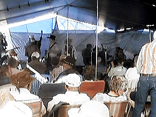 The Tuesday afternoon Music Jam is continuing. They announced today that attendance had broken all previous records for this year (the first year for LaPosa South) from November until now. Two hundred and thirty seven people came to hear the musicians do their things. The afternoon is free but you can donate if you like, and the money goes to offset the expense of the tent and the sound equipment. Also, if you like, you may participate... sing, play an instrument, tell a story, just entertain and 'keep it clean' they say. Who knows, next year I may give it a go myself. After all, Tuesday was my birthday and I have completed 63 years ... it's about time I started looking for my fifteen minutes of fame!
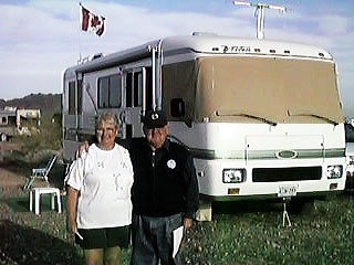 Our neighbors, Marie and Harold Drummond, from Canada came over while Steve was carving to see what he was doing. They invited us to a campfire they were going to have this evening. They had invited a couple of other couples as well. It was really neat because everyone told life's stories. Dan and Jackie also from Canada, have spent time in Alaska. Jay and Sherlene had lived in Alaska for 12 years and now live in southern Idaho. Harold and Marie had lived in Alaska and have traveled extensively in the Yukon and other Canadian provinces. Harold composed a
 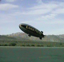 Ahead of us we could see mountains on both sides and they looked to be joined by a straight, flat surface against the sky, sort of like when you approach a dam from downstream. But we could see the highway went up over it and assumed it was Chiriaco Pass. When we reached the pass we got off the highway to refuel at the Chevron station, as pushing into the wind for so long going uphill had emptied our tanks. The General George Patton Museum is here. We had planned to stop and visit it but we weren't quite sure where it was. We noticed a van labeled Good Year was parked by a restaurant there and then we saw an eighteen wheeler and a bus also with Good Year on the sides. To my delight I looked to the east and the zeppelin was coming up over the pass!! We quickly filled our gas tanks and turned the rig around so we could fill the generator's tank also, then we drove out to where the Good Year truck had parked. There was a small airfield just a block or so to the north east of the filling station and the zeppelin was headed for a landing there. The crew from the van and the bus had run out there on foot to meet it and grab the anchor lines it had dropped. We got out the cam corder, binoculars, digital camera and watched the whole thing from along a fence that kept us from getting any closer. The crew refilled the aircraft and it took off again, headed west into the sunset. When the crew got back to the truck we asked where they would have to go next to dogcatch the blimp and they said they never quite know where the pilot is going to be next. After stowing the equipment they used they all loaded up and headed out.
 Activity: After breakfast we walked across the patch of desert to the George S. Patton, Jr. Memorial Museum. It opened at 9:30. We got there about 10 and there were already a lot of folks there. I can't imagine where they came from. This place is out in the middle of nowhere.
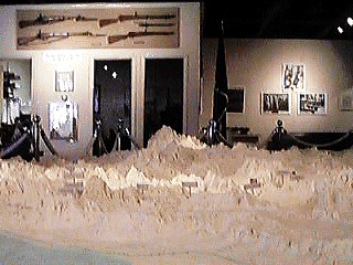 My favorite part of the whole place was the big 'map' on a 'table' that filled the entrance room. The 3 dimensional map almost covers a 20 x 20 foot space and weighs close to 5 tons. It was created for the Colorado River Aqueduct project and had been taken apart to transport to Washington, D.C. in 1928 for congressional hearings prior to the passage of the Boulder Canyon Act. Construction on CRA began in 1933 and water was delivered by the system starting in 1941. The Metropolitan Water District of Southern California donated the map to the Patton Museum in 1988. The map has different horizontal and vertical scales in order to keep it a manageable size, and is made of 250,000 jigsaw-like pieces of fiberboard to show the 50,000 square miles covered by the aqueduct project.